Durg | Chhattisgarh | Mysahar.in

About Durg Chhattisgarh.
Durg is a well-known and famous city in Chhattisgarh. Which is very famous for its temples. “Ganga Maiya” Jhalmala and “Uvassagramam Parva Tirtha ka Jain” are the famous temples here.
The Langurveer temple dedicated to Lord Langurveer is located only here in India. The population of Durg in 2011 was “2 lakh 68 thousand” in which there is a sex ratio of 982 females for every 1000 males.
Here the Shivnath river, also known as Senath, is situated, which has a total length of 290 km. Here about 60% of the people speak Chhattisgarhi, 25% in Hindi, and the rest in Odia, Marathi, Bhojpuri, Bengali, and Punjabi languages.
Famous Roads.
- Dhamdha / Bemetara Road
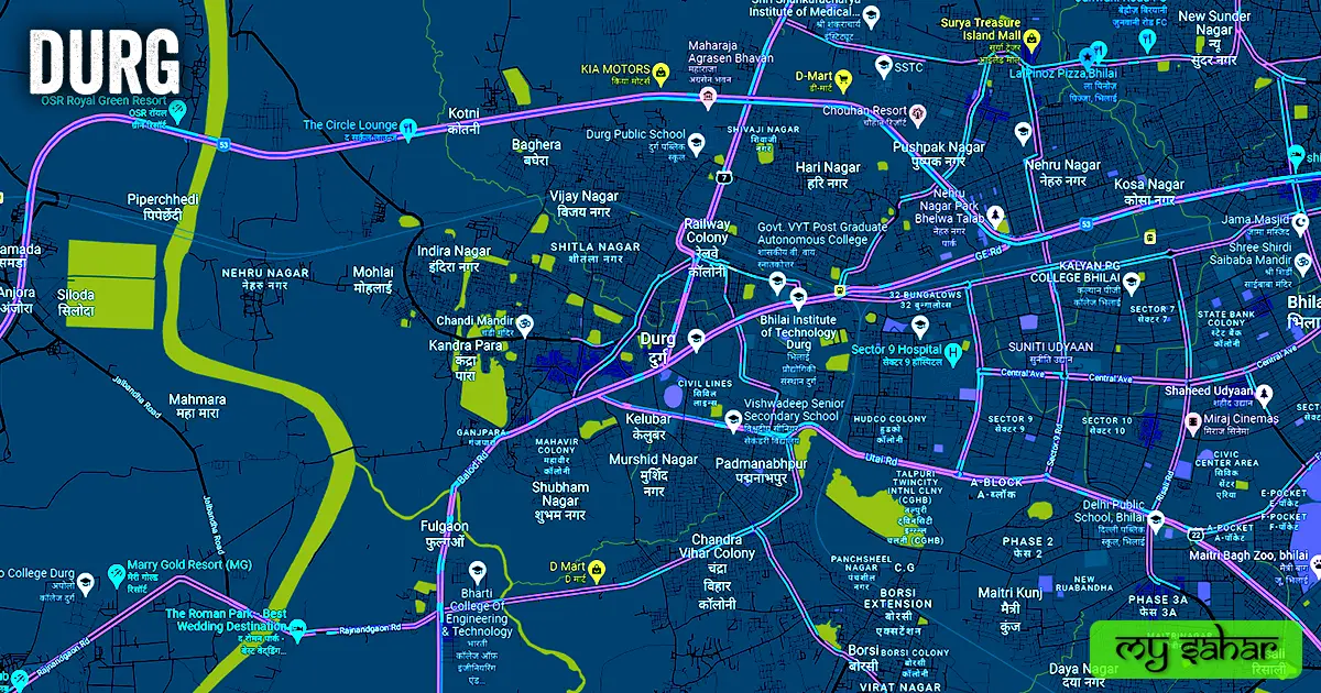
- Bypass Road (NH – 53)
- Utai Road
- GE Road
- Balod / Rajhara Road
- Pulgaon Road
- Chandi Mandir Road
- Shivnath River Brigde
- Nagpura Road
- Station Road
- Jail Road
- Padmanabhpur Pulgaon Pass Road
- Anda / Borsi Road
- Raipour Naka Overbridge
- Supela Road
- Gaurav Path
- Power House Flyover
- Raipur Bhilai Durg Expressway
Famous Chowks.
- Agrasen Chowk
- Indira Market Chowk
- Budh Vihar Chowk
- Patel Chowk
- Jail Tiraha
- Malviya Nagar Chowk
- Bharat Mata Chowk
- Rajendra Park Chowk
- Patel Chowk
- Gandhi Chowk
- Shipara Bajarang Chowk
- Prem Sagar Chowk
- Avanti Bai Chowk
- Shastri Chowk
Rivers And Lakes.
- Shivnath River
- Bandha Talab
- Talpuri Talab
- Thagda Talab
- Sheetla Talab
- Luchki Talab
- Harana Bandha Talab
- Borsi Talab
Ways Of Transportation.

Transportation is an essential element for the development of any city, which connects the city with many other cities and also makes trade easier. The following are the means of transportation here. The major ways of transportation here are roads, rail roots, and airways.
Roads – The NH-53 or AH46, SH-22, and SH-7 are the three national and state highways that pass through this city, which connect this city to big cities like – Raipur, Dhamdha, Rajnandgaon, Gunderdehi, Bhilai, and Abhanpur together.
Railways – It has railway stations which is a rail junction which means it has railway routes to several cities. Its station code is (DURG), The length of this station is about 745.87 meters and the width is about 138.22 meters. A total of 110 trains run at this station. Its next station is Bhilai Nagar station and its fourth is Rasmara.
Airways – Unfortunately, this city doesn’t have its own airport the people here have to rely on its nearest airport called (Swami Vivekanand International Airport) which is situated 56 km away in the west direction of the city. it takes almost 1 hour and 31 minutes to reach there. it’s an international airport so you can take international flights from this airport.
Pin Code Of City.
Often people also search on Google what is the pin code of this city. The complete form of a Pin Code is Postal Index Number Code. And the pin code of the city Head Office is – “491001”
Distance From Major Cities.
- Bhilai – 7 km
- Raipur – 37 km
- Bilaspur – 133 km
- Korba – 195 km
- Nagpur – 226 km
- Chandrapur – 247 km
- Jabalpur – 260 km
- Ramagundam – 328 km
- Amravati – 367 km
Latest Weather Updates.
The average temperature of the Durg is around 26.7 °C. And here on average 1052 mm (41.4 inches), every year of precipitation falls. For today’s weather information on this city, click on the link given below.
- Weather-forecast.com
- Weatheravenue.com
- Weather.ournet.in
News Agencies.
A list of some famous local news agencies is given below. These include newspapers, magazines, local news channels, etc.
- CG News India
- Vartamanmanthan.com
- Dainik Chintak
- Poorab Times
- IBC 24
- Nai Dunia
Best Parks.
- Nehru Nagar Park Bhelwa Talab
- Dada dadi Nana Nani Park
- Bal Udyan
- Shivaji Park
- Manas Vatika
- Panchratan Vatika
- Civil Line Public Park
- MR Durg Park
- Sri Sarvepalli Radha Krishna Park
- New Adarsh Nagar Park
Best Hospitals.
- Pandurang Ramarao Dongaonkar District Hospital
- Steel City Medical Center – Multispecialty Hospital
- Chandulal Chandrakar Memorial Hospital
- Rajvanshi Memorial Hospital
- Shri Balaji Hospital
- Jamul Hospital Kailash Nagar
- VY Hospital
- Mahima Hospital
- Amrit Kalash Hospital
- Sri Sai Hospital
Best Hotels.
- Hotel Avalon
- Hotel Al Zayqa
- Pleasure Club
- Hotel Alka Place
- Mahendra Greens
- Hotel Sagar International
- The Roman Park
- Hotel Punjab
- Hotel Kohinoor
- Hotel Grand Dhillon
Best Schools.
- Delhi Public School
- Jawahar Navodaya Vidyalaya
- BSP Senior Secondary School
- Government Model Higher Secondary School
- Government Boys Higher Secondary School
- Indu IT School
- Shree Shankar Vidyalaya
- Nalanda Academy
- Gandhi Memorial Higher Secondary School
- ST Thomas English School
Best Colleges.
- Dignity College of Architecture
- Bhilai Institute of Technology
- K. K. Modi University
- Chhattisgarh Engineering College
- Chhatrapati Shivaji Institute of Technology
- Sri Shankaracharya Engineering College
- Sun Engineering College
- Bharti College of Engineering and Technology
- Rungta College of Science and Technology
- Indian College of Agriculture and Agricultural Engineering
Geography Of Durg.

The area code of the City is – 0788. Its height is about 289 meters above sea level. Here the registration of vehicles is done in “CG-07”. this city has an area of 182 sq km. There is a total of “10 Police Stations” located in the city.
Official Government Websites.
- Official website of this city – Click here.
- Municipal Corporation’s website – Click here.
- Official Police Website – Click here.
Famous Areas Of City.
- Shadani Nagar
- Kelubar
- Murshid Nagar
- Adarsh Nagar
- Padmanabhpur
- Subham Nagar
- Chandkhuri
- Malviya Nagar
- Sikola Basti
- Motipura
- Adarsh Nagar
- Panchsheel Nagar
- Indira Nagar
Famous Places To Visit.
- Maitri Bagh
- Tandula Dam
- Siyadevi Temple
- Chandi Mandir
- Shiva Temple
- Sita Maiya Temple
- Ganga Maiya Temple
- Parsvnath Teerth
- Kukurdev Temple
- Uvasaggaharam Parshwa Teerth