Discovery of Korba | Mysahar.in

About Korba Chhattisgarh.
Korba is one of the famous cities of Chhattisgarh. Which is known for its coal mines and high mountains. The highest hill here is Mount Karila, whose height is almost equal to the Jeddah Tower of Saudi Arabia, which is going to be the world’s tallest building in the coming times.
And many of Asia’s largest coal mines are located in this city. Where 83 million tonnes of coal is mined per year. For that reason, this city is also known as the “Power City” of Chhattisgarh. There are more than 23 manufacturing industries established here, due to which it is called the “industrial capital” of Chhattisgarh.
According to the census, the population here is about “3 lakh 65 thousand”. Here there is a sex ratio of 927 females for every 1000 males. People in the city mainly speak Hindi, Kurukh, and Chhattisgarhi languages.
Famous Roads.
- State Highway – 4
- Champa Road
- TP Nagar Road
- Kathghora Bypass Road
- Bilaspur / Power House Road
- Poly Tech Road
- Devpheri Road
- Ring Road
- Balco Road
- Niharika / Kosabadi Road
- ITI Chowk Budhwari Road
- Budhwari Ghanta Ghar Road
- Station Road
- Stadium Road
- Rajgamar Road
- Collectorate Road
- Urga – Ridsi Bypass Road
- SECL Main Road
Famous Chowks.
- Maharana Pratab Chowk
- Jain Mandir Chowk
- CSEB Chowk
- Urga Chowk
- Shree Agrasen Tiraha
- Bajrang Chowk
- MP Nagar Chowk
- Subhash Chowk
Rivers And Lakes.
- Hasdo River
- Kesla River
- Dondro River
- Coal Ash Pond CSEB
- Ash Dyke
- Ash Dyke 2
- Old Mine Pond
- Mudadai Talab
- Bhadrapada Pond
- Bhadrapada Pond 2
- Ilahi Pond
- Pandit Talab
- Red Mud Pond
Ways Of Transportation.

Transportation is an essential element for the development of any city, which connects the city with many other cities and also makes trade easier. The following are the means of transportation here. The major ways of transportation here are roads, rail roots, and airways.
Roads – State Highway – 04, Champa Highway, Highways passing through this city, which connect cities like – Champa, Katghora, Sakti, and Hati together.
Railways – This city has a railway station in the middle of the city. Its station code is (KRBA). The length of this station is about 816 meters and the width is about 141 meters. A total of 12 trains run at this station.
Airways – This city has multiple helipads but doesn’t have its own airport so you have to go to its nearest airport which is (Bilasa Devi Kevat Airport) Located 100 kilometers away from here in Bilaspur city.
Pin Code Of City.
people also search on Google that what is the pin code of this city. The full form of Pin Code is (Postal Index Number Code). And the pin code of this city’s head office is – “495677”.
Distance From Major Cities.
- Katghora – 33 km
- Champa – 48 km
- Sakti – 56 km
- Bilaspur – 92 km
- Pathalgaon – 102 km
- Ambikapur – 173 km
- Raigarh – 112 km
- Raipur – 216 km
- Bhilai – 245 km
- Durg – 252 km
Latest Weather Updates.
The average temperature of this city is around 34°C. And here on average 467 mm (18.3 inches) of precipitation falls every year. Below are some websites from where you can get weather information.
- justweather.org
- www.weathercrave.com
- www.skymetweather.com
News Agencies.
A list of some famous local news agencies is given below. These include newspapers, magazines, local news channels, etc.
- City Hot News
- INN 24
- Blackout News
- Grand Gumber News
- Kuldeep News Agency
- AAdhar Stambh
Best Parks.
- Silver Jubilee Park NTPC
- Appu Garden
- Smriti Park Niharika
- Nehru Park
- Nehru Nagar Maidan (Park)
- Smriti Udayan
- Shivaji Nagar Garden
- Sarvamangala Park
- MP Nagar Garden
- Children’s Park, Ghantaghar
Best Hospitals.
- N.K.H. Super Specialty Hospital
- Shree Balaji Trauma & Super Specialty Hospital
- C.S.E.B. Hospital,
- Acai’s Hospital
- City Hospital
- Krishna Hospital
- S.E.C.L. Main Hospital
- Harish Nayak Hospital
- Indira Gandhi District Hospital
- Jaypee Surgical Hospital and Advanced Laparoscopic Centre
Best Hotels.
- Hotel Vishram Regency
- Hotel City Point
- Hotel Grand Govinda,
- Hotel Brindavan
- Hotel Akash
- Hotel Satkar Deluxe
- Hotel Center Point
- Hotel Deendayal
- Blue Diamond Hotel
- Hotel Downtown
Best Schools.
- Government Higher Secondary School
- Government Boys Higher Secondary School
- Kendriya Vidyalaya
- Government Higher Secondary School
- Delhi Public School
- Dev Public School
- Government Girls Higher Secondary School
- D D M Public School
- St. Xavier’s Public School
- Nirmala CBSE School
Best Colleges.
- Kamala Nehru College – [KNC]
- City Computer College
- Shri Agrasen Girls College – [AGC]
- Institute of Technology – [IT]
Geography Of Korba.

STD code of the city is “07759” Its height is about (316 meters) above sea level. Here the registration of cars/bikes and all vehicles is done in “CG-12”. The area of this city is (286.81 km²) and the border is about 77.36 km. There is a total of “6 Police Stations” situated in this city.
Official Government Websites.
- City’s Official website – Click here
- Municipal Corporation’s website – Click here
- Official Police Website – Click here
Famous Areas Of City.
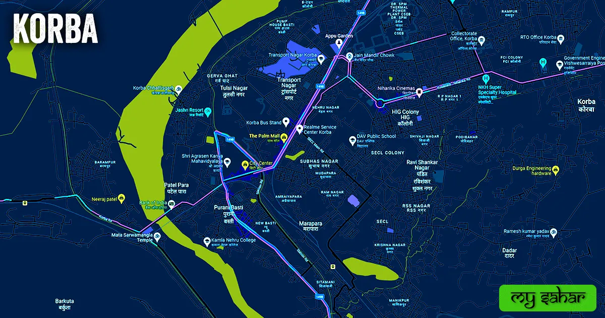
- Sonpuri
- Maraapara
- Urga
- Bhar Bhaspur
- KukriCholi
- Dadar
- Mahavir Nagar
- Subhash Nagar
- Tulsi Nagar
- Patel Para
- Purani Basti
- Balco Nagar
- Transport Nagar
Famous Places To Visit.
Temples & Mosques –
- Sankatmochan Hanuman Mandir
- Mata Sarwamangla Temple
Tourist Attractions –
- Bango Dam
- Silver Jubilee Park NTPC
- The Palm Mall
- Kesla Picnic Spot Balco
- City Center
- Dev-Pahari Waterfall
- Shopper’s Mart
- S.S.Plaza
- Jai Meera Garden
- Indira Stadium
- Aroma
- Sarvmangla Bridge
- Central Ground SECL
Restaurants & Cafes –
- The Chai Bar
- Grill Innternational resturant