Amravati | Maharashtra | Mysahar.in

About Amravati Maharashtra.
In the state of northern Maharastra, 155km far away from Nagpur the city of Amravati is located. Which is known for its mythological temples, cotton production, and production of electronic products. There has been a lot of expansion of industries here in the last few years. In which a total of 24 industries of products like Scientific Equipment, Laboratory Equipment, microscopes, ovens, Welding Electrodes, Pipe, etc are located here.
The number of which may increase even more in the future. If we talk about temples, then here Ambadevi temple, Venkateswara Swamy, and Shri Krishna temple are famous all over India. Amravati is also known for its agriculture, especially the cultivation and distribution of cotton. Which is prepared and sent to big cities like Gujarat, Mumbai, and Kolkata.
Amravati’s name literally means “abode of the immortals”. There are many other ancient names for Amravati such as – Audumbravati, and Ambanagri. The reasoning behind this name is that it got its name from the ancient temple of Ambadevi. And it is also said that it got this name due to the large number of Audumber trees here. At present none of the arguments have been fully substantiated.
Amravati was founded in the late 18th century. However, before 1965 it used to be a part of Madhya Pradesh which was later merged with Maharashtra. According to the census, about “6 lakh 46 thousand” people live here. In which there is a sex ratio of 957 females for every 1000 males. People here use Marathi and Hindi languages in their daily life.
Famous Roads.
- Kurha Road
- Mother Teresa Road
- Morshi Road (NH – 53)
- Bypass Road
- Purana Bypass Road
- Paratwada Road
- Tivsa Achalpur Road
- Valgone Road
- Panchvati Flyover
- Maltekdi Road
- Camp Road
- Badnera Road
- Shegaon – Rahatgaon Road
- Netaji Subhas Chandra Bose Rd
- Shilangan Road
- Station Road
- Ring Road
Famous Chowks.
- Jaistambh Chowk
- Shyam Chowk
- Chandani Chowk
- Biyani Square
- Arjun Nagar Square
- Chatrapati Shahu Square
- Tagore Chowk
- Shegaon Naka
- Maharishi Square
- Panchvati Square
- Irwin Square
- Amba Gate
- Yasmin Nagar Chowk
Rivers And Lakes.
- Pedhi River
- Chatri Talab
- Wadali Talab
- Ghat Khed Lake
Ways Of Transportation.

Transportation is an essential element for the development of any city, which connects the city with many other cities and makes trade more accessible. The following are the means of transportation of Amravati. The major ways of transportation here are roads, rail roots, and airways.
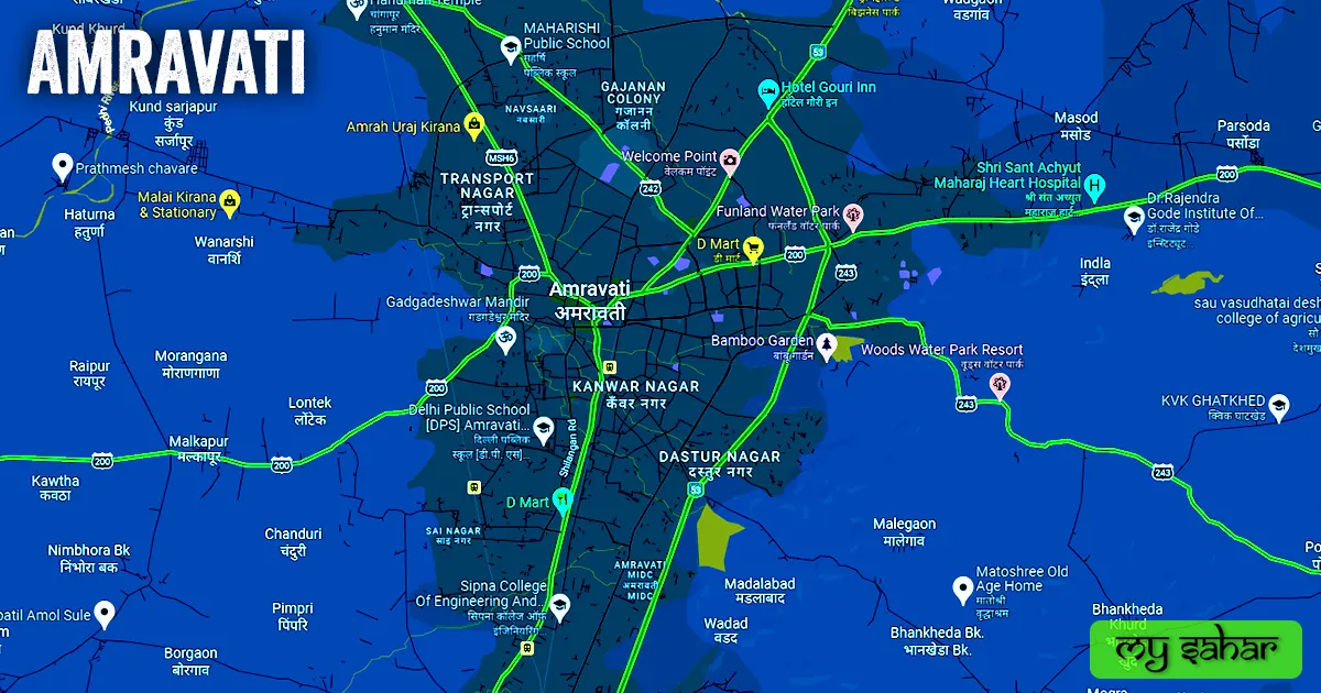
Roads – NH-53, SH-194, SH-242, SH-200, SH-243, SH-199, and MSH-6 are the seven major state and national highways that pass through Amravati city, which connect this city to other cities like – Nagpur, Wardha, Akola, Yavatmal, Multai, Paratwada, Karanja and Morshi together.
Railways – Amravati has two railway stations named (Amravati Railway Station and New Railway Station). Its station’s station code is (AMI). Its length is about 726.63 meters and its width is about 60.97 meters. a total of 9 trains arrive here and it has a total of 4 platforms in operation.
Airways – Amravati has an airport but it’s a small airstrip and only government officials can use this airport. so for any flight people have to go to its nearest airport known as (Dr. Babasaheb Ambedkar International Airport). which is situated 127 km far away in the east direction from here in Nagpur city. It takes almost 2 hours and 52 minutes to reach there.
Pin Code Of City.
people also search on the internet that what is the pin code of Amravati. The full form of the PIN Code is Postal Index Number Code. And the pin code of the city’s Head Office is – “444601”
Distance From Major Cities.
- Akola – 81 km
- Nagpur – 142 km
- Burhanpur – 163 km
- Chandrapur – 195 km
- Nanded – 203 km
- Parbhani – 211 km
- Jalna – 229 km
- Nizamabad – 255 km
- Bhopal – 262 km
Latest Weather Updates.
The average temperature of Amravati is around 33.4°C in summer and 20.5°C in winter. And here on average 781mm (30.78 inches), every year of rainfall happens. It rains here for about 44 days every year. For today’s weather information about Amravati City, click on the link given below.
- Weatherbug.com
- Imdnagpur.gov.in
- Wunderground.com
Watch YouTube Video.
Don’t Want to read watch this video instead and get all of your answers about Amravati.
News Agencies.
A list of some famous local news agencies of Amravati is given below. These include newspapers, magazines, local news channels, etc.
- Vidarbha 24 News
- Mandal News
- Enava Bharat
- ETV Bharat
- Pratidina Khbar
- Divya Marathi News
- Jagran
Best Parks.
- Vivekananda Park
- Padhey Garden
- Shiv Tekdi
- Panjabrao Deshmukh Garden
- Municipal Park
- Rajiv Gandhi Udyan
- Shiv Udyan
- Balaji Garden
- Rampuri Camp Park and Gardern
- Bamboo Garden
Best Hospitals.
- Yadgire Super Specialty Hospital
- Getlife laser piles clinic
- District General Hospital
- Zenith Hospital Tertiary Care Center
- Radiant Superspeciality Hospital
- Sai Multispeciality Hospital
- Chintamani Hospital
- Sanjeevan Multispeciality Hospital
- Hi-tech Multispeciality Hospital
- Super Speciality Hospital
Best Hotels.
- The Grand Mehfil
- Hotel Gouri Innternational
- Hotel Rangoli Pearl
- Hotel Adarsh Desi Vilayti
- Hotel Excel Executive
- Hotel Grace Innternational
- Hotel Hindustan International
- Hotel Relish Residency
- Up & Above
- Empire Stay
Best Schools.
- School Of Scholars
- Orchid City International School
- Harikisan Maloo International School
- Delhi Public School [D.P.S]
- St. Francis High School
- Harikisan Maloo English School
- Abhyasa English School
- Podar International School
- School Of Connoisseurs
- SDF English Schools
Best Colleges.
- Sri Hanuman Vyayam Prasarak Mandal’s College
- Government College of Engineering
- P.R.Patil Group of Educational Institutes
- Degree College of Physical Education
- Vidyabharati. I. T. I
- Arts, Commerce & Science College
- Prof Ram Meghe College of Engineering
- Dr. Panjabrao Alias Memorial Medical College
- Narsamma Hirayya Arts Commerce & Science College
- Sipna College Of Engineering And Technology
Geography Of Amravati.

STD code of Amravati is “0251” Its height is about (343 meters) above sea level. Here the registration of cars, bikes, and commercial vehicles is done in “MH-27”. The area of this city is (97.2 kilometers square). There is a total of “13 Police Stations” situated in this city.
Official Government Websites.
- Official website of Amravati – Click here.
- Municipal Corporation’s website – Click here.
- Official Police Website – Click here.
Famous Areas Of City.
- Kanwar Nagar
- Dastur Nagar
- Transport Nagar
- Madhu Chandra Colony
- Vivekanand Colony
- Hazrat Bilal Nagar
- Buddha Vihar
- Shiv Sakti Nagar
- Nai Basti
- Belora Hirapur
- Juni Kotwali
- Amba Peth
- Siddhivinayak Nagar
- Pratik Nagar
- Arjun Nagar
Famous Places To Visit.
- Dreamz Landmark
- Ambadevi Temple
- Next Level Mall
- Melghat Tiger Reserve
- Shri Bhakti Dham Temple
- Gawilgarh Fort
- Woods water park resort
- Bamboo Garden
- Empire Mall
- Upper Wardha Dam
- Iskcon Temple
- JD Mall
- Wadali Talao
- City Center
- Devi Point
- Malkhed Dam
- Lords Bar And Restaurant
- Hurricane Point
