Discovery of Bilaspur | Mysahar.in

About Bilaspur Chhattisgarh.
The city of Bilaspur is well-known both throughout India and in the state of Chhattisgarh. It is renowned for its rice and wheat farming, particularly the Dubraj and Sharbati kinds. Conch shell, Thetri-khurmi, Tamater fatka, Green Bhaji, Cheela, Gulgulla bhajiya, Airsa, Angkar roti, etc. are also popular dishes made there.
This city is recognized all over the world for its significant industries in addition to its cuisine. It is the biggest power plant in Chhattisgarh, from which one name (NTPC) also derives. It produces so much power that it supplies not just the state of Chhattisgarh but also Delhi, the nation’s capital.
This is also where City Mall 36, the largest mall in the state, which has a total floor space of roughly 4.5 lakh square feet, is located. Because all the festivals are formally celebrated in this city, it is also known as the “City of Festivals”. In the same way that Diwali, Shivratri, Basant Panchami, Holi, Dussehra, Makar Sankranti, Chhath, etc. are celebrated. The Hindu deity “Bilasa Devi” is the source of the name of this city.
This is where the Chhattisgarh High Court is located. It came into existence on November 1st, 2000, along with the state. during the time that Madhya Pradesh and Chhattisgarh were split apart. In terms of population, this city is the second most populous in Chhattisgarh. In 2011, the city had a population of 7 lakh 50 thousand people. In their everyday lives, locals primarily speak Hindi, Chhattisgarhi, and Oriya.
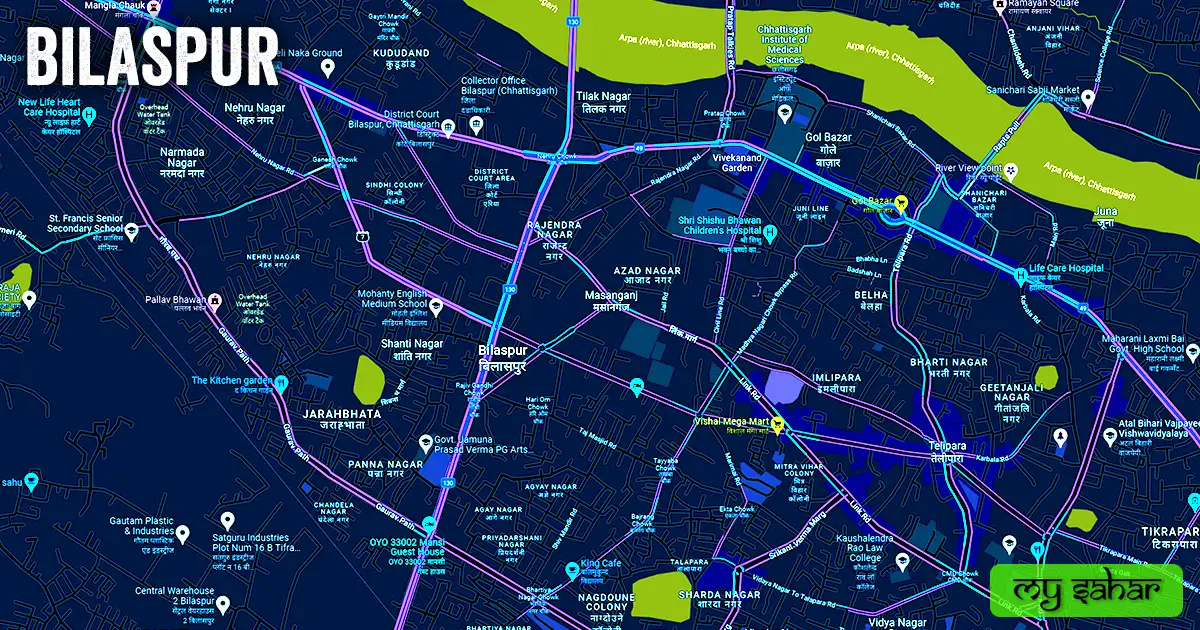
Famous Roads.
- Mungeli – Takhatpur Road
- NH – 49
- Korba Road
- Station Road
- Sipat Road
- Rapta Pul
- Mopka Bypass Road
- Telipara Road
- Link Road
- Gaurav Path
- Vyapar Vihar Road
- Birkona-Sarkanda Road
- Srikant Varma Road
- Marimai Road
- Magarpara Road
- Taj Masjid Road
Famous Chowks.
- Gol Bazar
- Tulja Bhawani Mandir Chowk
- Sipat Chowk
- Bilasa Chowk
- Rajendra Nagar Chowk
- Rajiv Gandhi Chowk
- Maharana Pratab Chowk
- Rabindranath Tagore Square
- Shivaji Chowk
- Satyam Chowk
- Eidgah Chowk
- Milan Chowk
- Gandhi Chowk
- Dayalband Chowk
- Madhya Nagari Chowk
- Power House Chowk
- Ganesh Chowk
Rivers And Lakes.
- Apra river
- Kopra Dam
- NTPC Rakhad Dam
- Karbala Talab
- Mama Bhancha Talab
- Ashnam Lake
- Jatiya Talab
- Zora Talab
- Kali Mandir Talab
- Bandhwa Talab
- Rajim Talab
- Naag Nagin Talab
- Chunni Singh Talab
- Janji Talab
There are sources of water here.
Ways Of Transportation.

As it connects a city to several other cities and promotes trade, transportation is an important factor in every city’s economic growth. The available modes of transportation are as follows: Roads, rail lines, and airways make up the main modes of transportation in this area.
Roadways – The three national highways that travel through this city are NH-49, NH-130, and NH-130A. These three national highways link Bilaspur to other cities, including Janjgir Champa, Pandariya, Katghora, and Simga.
Railways – This station, which is a juncture connecting lines to various cities, has the station code (BSP). This station is approximately 1.23 kilometers long and 185.35 meters wide. At this railroad station, 89 trains run simultaneously.
Air travel – Bilasa Devi Kewat Airport, the sole airport in the city, lies 10 kilometers from Bilaspur’s center at Chakarbhatta. The Royal Air Force constructed it in 1942.
Pin Code Of City.
What this city’s pin code is is another question that people seek on Google. A pin code’s entire form is a “Postal Index Number Code.” And 495001 is the pin code for the main office in this city.
Distance From Major Cities.
- Korba – 64 km
- Raipur – 106 km
- Bhilai – 128 km
- Durg – 133 km
- Ambikapur – 199
- Jabalpur – 256 km
- Raurkela – 283 km
- Rajnandgaon – 319 km
Radio Stations
- Radio Raman – 90.4MHz
- Radio FM Tadka – 91.1MHz
- Radio Orange – 91.9MHz
- Radio Rangila – 92.7MHz
- My FM – 94.3MHz
- All India Radio – 103.2MHz
Latest Weather Updates.
This city’s typical temperature is about 26.8 °C. 40 degrees Celsius is the highest temperature ever recorded, while 10 degrees Celsius is the lowest. And there, annual precipitation averages 1259 mm (49.6 inches). Click the link below to see information about the weather today.
- www.accuweather.com
- www.timeanddate.com
- www.weather.com
News Agencies.
The list of notable local news organizations is shown below. They include periodicals, local news channels, newspapers, and magazines.
- Hari Bhumi
- Lokswar Press
- The City Power News
- Shubhsanket News
- News36 Live
- The YWN News
- Chhattisgarh Reporter
Best Parks.
- Deendayal Upadhyay Udyan
- Fantasia Roman Thema Park
- Nagdoni Colony Garden
- Kanan Pendari Zoological Garden
- Bilasa Tal Vasundhara Udyan
- Traffic Park
- Priyavaran Udayan
- Shri Ram Park
- Konher Garden
- Ram Ghati Vivekananda Park
Best Hospitals.
- Shri Balaji Hospital
- Shri Ram Care Hospital
- Apollo Hospital
- Samdhan Nursing Home
- Dr. Manoj Rai Best Hospital
- Care N Cure Super Specialty Hospital
- Ekta Hospital
- KIMS Superspecialty Hospital
- Endoscopy and Surgical Clinic (Cancer Hospital)
- Srishti Children’s Hospital
Best Hotels.
- Courtyard By Marriott
- The Partisans
- Hotel East Park
- Shivam I N
- Hotel Raja
- The Ananda Imperial
- Hotel Silver Ovac
- Hotel Natraj
- Hotel Vinayak Palace
- Sai Yatri Niwas
Best Schools.
- Jawahar Navodaya Vidyalaya
- Delhi Public School (DPS)
- (DAV) Public School
- ST Francis Higher Secondary School (SFC)
- The Jain International School
- Shaskiye Boys Higher Secondary School
- Maharishi Vidya Mandir
- Central School
- Brilliant Public School
- Shri Kailashpat Singhania School
Best Colleges.
- DP Vipra Law College
- DLS PG College
- Sandipani Academy
- JK Institute of Engineering
- SBT College (SBT)
- Shubham B.Ed College
- GTB College (GTB)
- Kaushalendra Rao PG Law College
- Government PT Madhav Rao Sapre College
- Drona College of IT and Applied Social Sciences
Geography Of Bilaspur.

It has the area code 07752. Its elevation above sea level is approximately 207 meters. Vehicle registration is carried out at “CG-10” here. Its area is approximately 205 km². There are 20 police stations in the city as a whole. found here.
Official Government Websites.
- Official Police Website – Click here
- City’s Official website – Click here
- Municipal Corporation’s website – Click here
Famous Areas Of City.
- Gol Bazar
- Tilak Nagar
- Vidya Nagar
- Masanganj
- Jarahbhata
- Panna Nagar
- Telipara
- Juna
- Fadahakhar
- Dayalband
- Bharti Nagar
- Tikra Para
- Bangalipara
- Belha
- Vypar Vihar
- Rajkishor Nagar
- Uslapur
Famous Places To Visit.
Tourist Attractions –
- City Mall 36
- Kanan Pendari Zoological Garden
- Rama Magneto – The Mall
- Madku Deep
- Kutghat Dam
- Bubble Iceland
- Sanjay Taran Pushkar
- Dipu Para Lake
- Kanan Pendari Zoo Park
- Deendayal Upadhyay Garden
- Achanakmar Tiger Reserve
Restaurants & Cafes –
- Caffeeba
- Murg Massallam
- Sanjha Chulha
- Cafe Ibiza
- Maosaji SVM
Temples & Mosques –
- Maa Kali Mandir Tifra
- Taj Masjid
- Dhanteswari Temple
- Mahamaya Devi Temple
- Juna Masjid
- Chuchaiyapara Masjid
- Devrani Jethani Temple
Movie Theaters –
- Carnival Cinemas
- PVR Cinemas
- Jeet Talkies
- Shiv Talkies