Ichalkaranji | Maharashtra | Mysahar.in

About Ichalkaranji Maharashtra.
28km faraway from Kolhapur city in the state of southern Maharastra, Ichalkaranji city is situated and located under Kolhapur district. Which is known for its exceptional quality textile manufacturing industries and large-scale sugarcane production. The textile and yarn industry here is so big that you can guess it from the fact that every year revenue of about “31 thousand 300 crores” rupees is generated from the manufacture of clothes and exports abroad, which is huge in terms of revenue.
And almost 10 million meters of cloth are produced per day in Ichalkaranji, it seems impossible but it is true. On the other hand, if we talk about the income from sugarcane production, then around 1 thousand 300 crore rupees of business is done in Ichalkaranji every year. Not only this but Ichalkaranji is also called the “Manchester of Maharashtra”, which was due to the growing industrial revolution here.
This is the reason that in search of employment, laborers from many states knock here. According to the figures, more than 50000 people have got employment in Ichalkaranji, who do only weaving-related work. If Ichalkaranji is called a small India, then it should not be a surprise because so many types of people live here. People of many castes and many religions reside and celebrate their cultural festivals together without any bias.
Here people have to face a lot of trouble in traveling by train because Ichalkaranji does not have its own railway station. Due to this people have to go to the station of Hatkanagale city 10 km away to travel. According to the 2011 census, about “2 lakh 87 thousand” people reside here. In which there is a sex ratio of 925 females for every 1000 males. The people of Ichalkaranji mainly use Marathi, Hindi, Kannada, and English as their local languages.
Famous Roads.
- Sangli Road
- Station Road
- Main Road
- Korochi Road
- Nandani Road
- Kolhapur Road
- Kurundwad Road
- Nadives Road
- Ring Road
- Rajaram Road
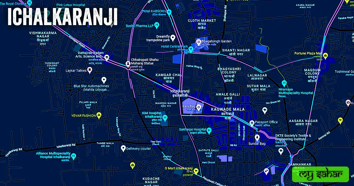
- Panchvati Talkies Road
- Kalangar Ring Road
- Vadige Galli
- Aamrai Road
- Takwade, Sangli Naka Road
- Chandoor Road
- Panchganga Sugar Factory Road
Famous Chowks.
- Chhatrapati Shivaji Chowk
- Chhatrapati Shahu Chowk
- Zenda Chowk
- Limbu Chowk
- Satkon Chowk
- Sangarm Chowk
- Teen Batti Chowk
- Chandani Chowk
- Hatti Chowk
- Ambedkar Chowk
- Thakre Chowk
- Mahatma Gandhi putla
Rivers And Lakes.
- Panchganga River
Ways Of Transportation.

Transportation is an essential element for the development of any city, which connects the city with many other cities and also makes trade easier. The following are the means of transportation in Ichalkaranji. The major ways of transportation here are roads, rail roots, and airways.
Roads – Ichalkaranji only has one SH-78, this state highway ends in this city, which connects this city to other neighboring cities like – Baragaon, Kolhapur, Herwad, Kurundwad, and Sangli together.
Railways – Ichalkaranji doesn’t have its own railway station so in case of any train journey people have to go to its nearest station which is (Hatkangale Railway Station) it is located 8.3 km away in the north direction of the city in Hatkangle and its station code is (HTK).

Airways – Ichalkaranji doesn’t have its own airport. so people have to go to its nearest airport known as (Kolhapur Airport) which is located 30.3 km away in the west direction from here in Kolhapur city. It takes nearly 46 minutes to reach there.
Pin Code Of City.
people also search on the internet that what is the pin code of Ichalkaranji. The full form of the PIN Code is Postal Index Number Code. And the pin code of the city’s Head Office is – “416115”
Distance From Major Cities.
- Boragaon – 13 km
- Kurundwad – 20 km
- Kolhapur – 24 km
- Belgaum – 93 km
- Bijapur – 132 km
- Hubli – 168 km
- Solapur – 187 km
- Pune – 214 km
- Pimpri – 225 km
- Gulbarga – 262 km
Latest Weather Updates.
The average temperature of Ichalkaranji is around 38°C in summer and 12°C in winter. And here on average 582.7mm (22.94 inches), every year of rainfall happens. It rains here for about 135 days every year. For today’s weather information about Ichalkaranji, click on the link given below.
- Weather-forecast.com
- Meteoblue.com
- Weatherspark.com
Watch YouTube Video.
Don’t Want to read watch this video instead and get all of your answers about this city.
News Agencies.
A list of some famous local news agencies of Ichalkaranji is given below. These include newspapers, magazines, local news channels, etc.
- India Policenews
- Smart Sindi
- Smar Tichi
- Emaha Satta
- Esakal
- MSK Digital News
Best Parks.
- Sahid Bhagatsingh udyan
- Rani Bag
- Kulkarni Garden
- Tardale Garden
- Chatrapati Shivaji Maharaj Udyan
- Bhagatsingh Garden
- Sundar Bag
- Mahalakshmi Garden
- Matarmai Garden
- Pandit Jawaharlal Nehru Udhyan
Best Hospitals.
- Alliance Multispeciality Hospital
- Aadhar Hospital
- Dr. Pathan Hospital
- Sahayog Eye Hospital
- Niramaya Multispeciality Hospital
- Mahadik Orthopaedic Hospital
- Pink Lotus Hospital
- Lata Surgical Hospital
- Dr. Ashok kajave Children Hospital
- Ruikar Children’s and Women’s Hospital
Best Hotels.
- Grand Fortune
- Hotel Signature
- Hotel Runwal Tower
- Hotel Hirkani
- Hotel Rajdoot Royale Residency
- Heritage Resort
- Hotel Mangalam
- Hotel Pavan’s family Restaurant And Bar
- Hotel Sonali
- Om Executive AC Deluxe Lodge
Best Schools.
- Sunrise International Pre School
- Anna Ramgonda Government School
- Lord Jiweshwar English Medium School
- Shankarav Jadhav Vidyamandir
- Dr. Jaya Adinath Chougule Primary School
- Global English School
- Podar International School
- Adarsha Vidya Mandir
- Sai English School
- Marathi medium high school
Best Colleges.
- Shri Venkatesh Mahavidyalaya
- Dattajirao Kadam Arts, Science and Commerce College
- Sharad Institute of Technology College of Engineering
- High school And Junior College
- City BED college
- Kanya Mahavidyalay
- Shikashanshatra mahavidyalay
- Sanjay Ghodawat IIT & Medical Academy
- DKTE Society’s Textile & Engineering Institute
- Shikshan Shastra Mahavidyalaya
Geography Of Ichalkaranji.

The area code of Ichalkaranji is “0230” Its height is about (539 meters) above sea level. Here the registration of cars and bikes is done in “MH-09”. The area of this city is (49.84 square kilometers). There is a total of “7 Police Stations” situated in this town.
Official Government Websites.
- Official website of Ichalkaranji – Click here.
- Municipal Corporation’s website – Click here.
- Official Police Website – Click here.
Famous Areas Of City.
- Vikash Nagar
- Rajwada
- Mahadev Nagar
- Kamgar Chal
- Shanti Nagar
- Vivekanand Nagar
- Mukund Nagar
- Khotvadi
- GK Nagar
- Chavanmala
- Renuka Nagar
Famous Places To Visit.
- Shree Tulja Bhawani Temple
- Grand Fortune Mall
- Tulja Bhavani Temple
- ISKCON Center
- Royal Plaza Warana Milk
- Markandey Mandir
- Fortune Plaza Mall
- Aa Ha food court
- Indian Chinese Center
- Shri 108 Chandraprabhu Digambar Jain Mandir
- Balaji Bakers, Yadrav Phata Temple
- Runwal Tower
- Shri Vasupujya Bhagwan Jain Temple
- Hotel Central Park
- Avanti Vada Centre
- MBK Complex
